

If you love exploring the outdoors or need to find local information, you have probably heard of the Dorset Explorer. It is a powerful, free tool provided by the Dorset Council. Whether you are a hiker looking for a new path, a history buff curious about old maps, or a resident checking school catchments, this tool is for you.
Using the Dorset Explorer is like having a superpower for your phone or computer. It lets you see layers of information that you can’t find on a regular map. In this guide, I will show you exactly how to use it, why it’s so helpful, and some personal tips I’ve learned while planning my own trips through the beautiful Dorset countryside.
What is the Dorset Explorer Map?
The Dorset Explorer is a web-based mapping application. It is designed to give everyone—from council staff to the general public—access to geographic data. Think of it as a digital “onion.” You can peel back or add layers to see different things.
When you first open it, you see a modern map. But with a few clicks, you can turn on aerial photography, see where public footpaths are, or even look at “ghost” maps from the late 1800s. It’s an essential tool for Dorset nature recovery and local planning.
Key Features of the Dorset Explorer Tool
| Feature | What it Does | Why You’ll Love It |
| Interactive Layers | Adds data like rights of way or habitats. | Helps you plan safe and legal walking routes. |
| Historic OS Maps | Shows Dorset in the late 1800s. | Great for seeing how your town has changed. |
| Aerial Photography | High-resolution views from the sky. | Perfect for checking terrain before you visit. |
| Measurement Tools | Measures distance and area. | Calculate exactly how long your hike will be. |
| Search Function | Finds addresses or coordinates. | Quickly jump to any spot in the county. |
| Geolocation | Tracks your real-time position. | Keep from getting lost while out in the fields. |
How to Use Dorset Explorer for Walking and Hiking
One of my favorite ways to use the Dorset Explorer is for planning weekend walks. Most map apps don’t show the difference between a private road and a “Right of Way.” This map does.
To start, open the “Layers” panel. Look for the “Countryside” folder. Here, you can toggle on “Public Rights of Way.” Instantly, purple or green lines appear. These are the paths where you are legally allowed to walk. This is much more reliable than just following a trail on a standard GPS, which might lead you into a farmer’s private backyard!
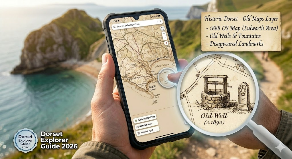
Exploring the History of Dorset
Have you ever wondered what was on your street 100 years ago? The Dorset Explorer makes this easy. By switching to the “Historic Dorset” version, you can access datasets from the Dorset History Centre.
I once used this to find an old well that used to be near my friend’s house. Using the “Historic OS Maps” layer from the late 19th century, I could see buildings and landmarks that have long since disappeared. It’s a wonderful way to connect with the past while standing in the present.
Planning for Nature and Wildlife
The Dorset Explorer is also a champion for the environment. There is a specific version called Nature Recovery Dorset. This version is used by conservationists and nature lovers to identify areas of national importance.
If you are interested in wildlife, you can turn on layers for habitats and ecological networks. You can see where ancient woodlands are or find Sites of Special Scientific Interest (SSSI). This helps us understand which areas need our protection and where nature is currently thriving.
Using Geolocation on Your Mobile
If you are out in the Purbecks or wandering through the New Forest border, you might get turned around. The Dorset Explorer has a “Keep Screen Awake” feature for mobile users.
By clicking the geolocation button, the map will show a little dot where you are standing. It’s very accurate! You can even draw a “track” of where you have walked and export it as a GPX file. This is a great way to save your favorite secret spots to share with friends later.
How to Customize Your Map View
The tool is very flexible. You aren’t stuck with just one view. You can change the “basemap” to look like a standard street map, a satellite image, or a simple grey background.
You can also add your own data. If you have a file from another hiking app (like a KML or GPX file), you can drag and drop it right onto the Dorset Explorer. It will show your custom path on top of the council’s official data. This makes it a “pro” tool for anyone serious about outdoor navigation.
Information for Residents and Businesses
It isn’t all about hiking and history. The Dorset Explorer is very practical for daily life.
- School Catchments: Check which school area a house falls into.
- Planning Applications: See where new buildings are being proposed near you.
- Property Boundaries: Get a better idea of land ownership and council-maintained areas.
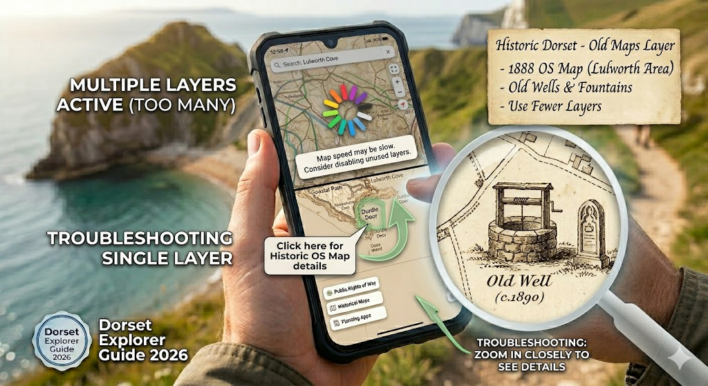
Important Tips for New Users
When you first use the tool, it can feel a bit crowded. My advice is to start simple. Turn off all layers and only turn on what you need. If you want to see the Dorset Explorer at its best, use a desktop computer first to get used to the controls, then switch to your phone when you are actually outside.
Also, remember that while the map is very accurate, “ground-truthing” is important. Sometimes a path on a map might be overgrown in real life. Always use your common sense when exploring!
Common Troubleshooting for Dorset Explorer
Sometimes the map might feel slow if you have too many layers on at once. If it freezes, just refresh the page. Also, remember that some layers only show up when you zoom in closely. If you click a layer and nothing happens, try zooming in on a specific town or field.
Frequently Asked Questions
1. Is the Dorset Explorer free to use?
Yes! It is a free service provided by the Dorset Council for everyone to use.
2. Can I use it on my iPhone or Android?
Yes, it works in your mobile web browser. It even has features specifically for mobile, like tracking your location.
3. How often is the map updated?
The council updates the data regularly. They often announce major updates for layers like nature recovery or planning.
4. Can I print maps from Dorset Explorer?
Yes, there is a “Print” tool that lets you create a PDF of your current map view to print at home.
5. Does it show private land?
It shows property boundaries and public rights of way, which helps you identify what is public and what is private.
6. Can I see satellite images from the past?
Yes, the map includes aerial photography layers from different decades, so you can see how the land has changed.
Conclusion
The Dorset Explorer is more than just a map; it is a gateway to discovering the hidden secrets of the county. Whether you are searching for a peaceful walk, researching local history, or checking on environmental data, this tool provides everything you need in one place.
I encourage you to open the map today and search for your own neighborhood. You might be surprised by what you find! If you found this guide helpful, why not share it with a fellow explorer? Happy mapping!
1 Comment
Pingback: How to Screen Record on iPhone: Easy Step-by-Step Guide - My Province Town Condo